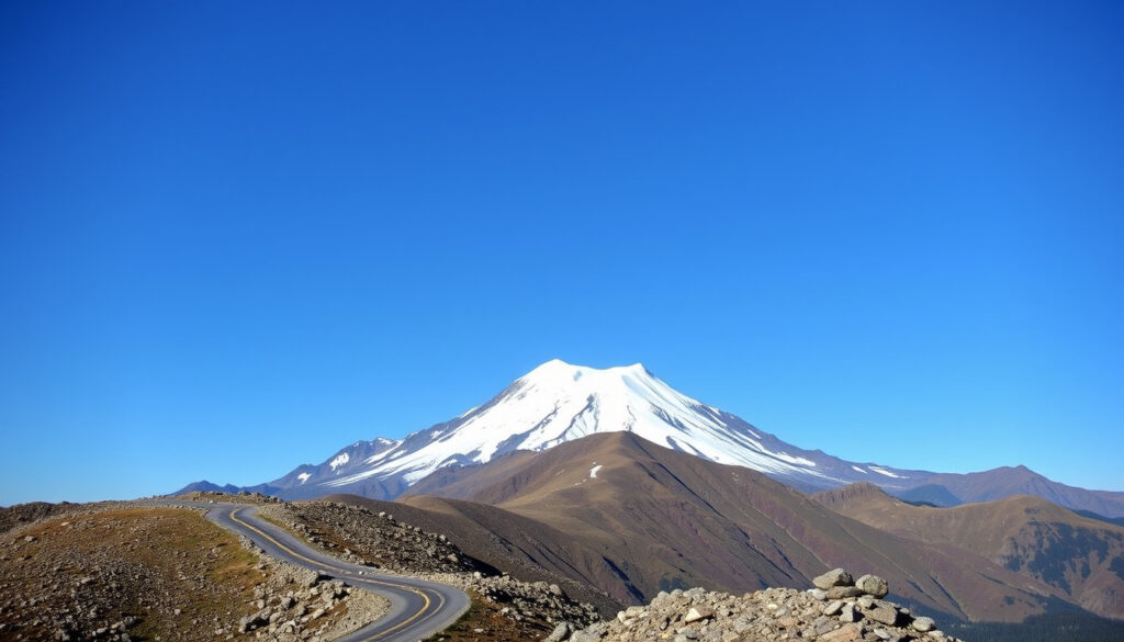
Mount Baker: Active Volcano, Beginner Climb & Scenic Drive
Few mountains in the Pacific Northwest pull double duty like Mount Baker does: by day, it’s an active stratovolcano under constant watch by the U.S. Geological Survey; by weekend, it’s a beginner-friendly climb and a ski area that once held the world record for single-season snowfall. Whether you’re planning a drive from Vancouver or eyeing your first glaciated summit, here’s what the data actually says — without the tourism brochure.
Elevation: 10,781 ft (3,286 m) ·
Location: Whatcom County, Washington, USA ·
Volcano type: Active stratovolcano ·
Last eruption: 1880 (confirmed) ·
First ascent: 1868 by Edmund Coleman, John Tennant, Thomas Stratton, David Ogilvy ·
Nearest town: Glacier, Washington
Quick snapshot
- Active volcano, last erupted 1880 (USDA Forest Service)
- 12+ glaciers covering 20+ sq mi (Alpine Ascents International)
- Heavily glaciated, lahar risk (U.S. Geological Survey)
- Exact timing of next eruption (USGS eruption history)
- Whether the 1843 event was a true eruption or phreatic explosion (USGS)
- Climate change impact on glacial stability (USGS)
- 1880: last confirmed eruption (USGS)
- 1975: increased fumarolic activity (USGS)
- 2024: ongoing steam/gas emissions (Cascades Volcano Observatory)
- USGS continues seismic and thermal monitoring
- Climbing season: May–September
- Ski season: October–May at Mt. Baker Ski Area
The key details that follow are drawn from official sources and guide services — no speculation.
| Attribute | Value |
|---|---|
| Elevation | 10,781 ft (3,286 m) |
| Location | Whatcom County, WA, USA |
| Volcano type | Stratovolcano (active) |
| Last eruption | 1880 |
| First ascent | 1868 |
| Prominence | 8,843 ft (2,696 m) |
| Nearest city | Bellingham, WA (30 mi) |
How long is the drive from Vancouver to Mount Baker?
What are the driving routes from Vancouver to Mount Baker?
The most common route from Vancouver, BC to the Mount Baker Ski Area is about 100 miles (161 km) and takes 2.5 to 3 hours under normal conditions. You take Highway 1 to the Peace Arch border crossing, then I-5 south to Bellingham, and finally State Route 542 (the Mount Baker Highway) east to the ski area. The USDA Forest Service (recreation page) notes that this highway is the primary access road.
How long does it take from Seattle?
From downtown Seattle, the drive to the Mount Baker Ski Area covers about 130 miles (209 km) and takes roughly 2.5 to 3.5 hours via I-5 north and SR 542. The route passes through Bellingham, where you can stock up on supplies.
What is the road condition in winter?
Washington State Department of Transportation requires winter tires or chains on SR 542 during snow season (typically November through March). Check WSDOT mountain pass reports for real-time conditions. The road is plowed up to the ski area, but sudden closures happen during storms.
The drive is manageable in good weather, but winter storms can add an hour or more. For Vancouver residents, the cross-border trip is shorter than driving to Whistler — but you need a passport or enhanced ID.
The implication: plan for extra time and always carry chains in winter.
What is the closest town to Mount Baker?
What amenities does Glacier, Washington offer?
The nearest community to Mount Baker is Glacier, Washington, located about 20 miles (32 km) from the Mount Baker Ski Area along SR 542. According to the USDA Forest Service (Summit Climbing page), Glacier has lodging (cabins, B&Bs), a handful of restaurants, and a general store. It serves as the last stop for fuel, food, and gear before heading up the mountain.
How far is Bellingham from Mount Baker?
Bellingham, the nearest city, is about 30 miles (48 km) west of Mount Baker. It offers full services: supermarkets, outdoor retailers, hotels, and hospitals. Many climbers stay in Bellingham the night before a summit attempt.
Why this matters: If you forget any critical gear — crampons, ice axe, or a proper rope — you will not find them in Glacier. Bellingham is your last reliable resupply point.
This means you should stock up in Bellingham before heading to Glacier.
Is Mount Baker still an active volcano?
What type of volcano is Mount Baker?
Yes, Mount Baker is an active stratovolcano. The U.S. Geological Survey (USGS eruption history) classifies it as a high-threat volcano because of its ice cap and potential for lahars (volcanic mudflows). According to the USDA Forest Service, the summit (Grant Peak) is actually a mound of ice hiding a volcanic crater. Sherman Crater, just south of the summit, is a center of periodic steam eruptions.
How is Mount Baker monitored?
The USGS operates a network of seismometers, GPS stations, and gas sensors on the mountain. In 1975, increased fumarolic activity prompted heightened monitoring. Steam and gas emissions continue today. The volcano is considered “quiet but active” — no eruption imminent, but not dormant.
If you plan to climb or ski near Sherman Crater, check the Cascades Volcano Observatory (CVO) alerts. Gas emissions can vary without warning.
The pattern: constant monitoring provides early warning, but the volcano remains unpredictable.
When did Mount Baker last erupt?
What was the 1880 eruption like?
The last confirmed eruption of Mount Baker occurred in 1880. The USGS eruption history describes it as a moderate explosive event that produced lava and tephra. Eyewitness reports from settlers and a Navy vessel documented ashfall and incandescence at the summit.
Are there any signs of recent activity?
No subsequent eruptions have occurred, but fumaroles (steam vents) near Sherman Crater remain active. In 2024, the USGS continues to record low-level seismicity and thermal anomalies. The volcano is not expected to erupt soon, but the monitoring apparatus is always tuned.
- ~6,600 years ago: Major explosive eruption deposits widespread tephra (USGS)
- 1843: Eruption reported by early settlers (possibly phreatic) (USGS)
- 1880: Last confirmed eruption (USGS)
- 1975: Increased fumarolic activity (USGS)
- 2024: Ongoing steam/gas emissions (CVO)
The pattern: Eruptions are rare, but the volcano remains thermally active. For skiers and hikers, the more immediate hazard is glacial crevasse or weather, not lava.
Can a beginner climb Mount Baker?
What skills are required?
Mount Baker is widely considered one of the best beginner glaciated climbs in the Cascades. Alpine Ascents International calls it “the perfect training ground for learning glacier mountaineering.” Basic glacier travel skills, crevasse rescue knowledge, and proper gear (crampons, ice axe, rope) are essential. No climbing permit is required, though some trailheads need a Forest Service recreation pass.
Do I need a guide?
First-time climbers should hire a guide or join an instructional program. Blackbird Guides describes the Coleman-Deming route as “the classic way to summit” and the most commonly guided. Several guide services offer 2- to 3-day courses that include skills training and a summit attempt.
What is the typical climb route?
Two main routes dominate: Coleman Glacier (north side) and Easton Glacier (south side). According to 57hours, the Coleman-Deming route is 11.8 miles round trip with 7,300 ft elevation gain. The Easton Glacier route is 12.5 miles and 7,500 ft gain. Both are rated “beginner” difficulty when guided.
Most programs run for three days, though fit climbers can attempt a two-day itinerary. The Northwest Alpine Guides offers a 2-day climb with a 90-minute skills refresher covering footwork, crampon technique, and rope-team fundamentals.
For a beginner, a guided 2–3 day course on the Coleman-Deming route is the safest way to summit.
Can you climb Mount Baker in one day?
What is the one-day climb route?
Experienced climbers can summit Mount Baker in a single day, typically via the Easton Glacier route. 57hours reports that this involves about 12.5 miles round trip and 7,500 ft of elevation gain. Alpine starts (2am) are standard to avoid afternoon snow softening and increased crevasse hazard.
What fitness level is needed?
One-day climbs demand excellent cardiovascular fitness and prior experience with glacier travel. The USFS recommends that most climbers attempt Baker over 2–3 days. Alpine Ascents notes that “the 2pm rule” applies: you must turn around by 2pm regardless of position, because afternoon snow conditions become dangerous.
A one-day climb saves time but increases risk from fatigue and late-day snow conditions. For a first ascent, three days gives you proper acclimatization and margin for error.
What are the risks?
The primary hazards are hidden crevasses, rapidly changing weather, and altitude (the summit is 10,781 ft). Northwest Avalanche Center issues daily avalanche forecasts for the range. Solo one-day ascents are done by experienced alpinists only.
One-day climbs are possible for experienced climbers but require excellent fitness and strict adherence to the 2pm rule.
Here are the main route options for climbing Mount Baker.
| Route | Distance (round trip) | Elevation gain | Difficulty | Typical time |
|---|---|---|---|---|
| Coleman-Deming | 11.8 mi | 7,300 ft | Beginner (guided) | 2–3 days |
| Easton Glacier | 12.5 mi | 7,500 ft | Beginner (guided) | 2–3 days |
| Boulder Glacier | ~12 mi | ~7,000 ft | Intermediate | 2–3 days |
| North Ridge | ~10 mi | ~6,500 ft | Intermediate | 1–2 days |
Upsides
- Beginner-friendly when guided
- No climbing permit needed
- Exceptional ski terrain (Oct–May)
- Accessible from Vancouver and Seattle
Downsides
- Active volcano — lahar risk
- Glacier travel required (crevasse danger)
- Weather can close roads and trails
- Limited services near the mountain
Step-by-step: Planning your Mount Baker climb
- Pick a route and dates. Choose between Coleman-Deming (classic) or Easton Glacier (late-season). Plan for 2–3 days.
- Book a guide or course. Companies like Alpine Ascents and Northwest Alpine Guides offer 2- and 3-day programs.
- Gather gear. Crampons, ice axe, helmet, mountaineering boots, rope, harness, glacier travel kit, and appropriate clothing. Rentals available in Bellingham.
- Acquire a recreation pass. Though no climbing permit is required, some trailheads (e.g., Heliotrope Ridge) require a Northwest Forest Pass.
- Check conditions. Monitor the USGS volcano page for activity updates and NWAC for avalanche forecasts.
- Arrive the evening before. Stay in Bellingham or Glacier (book ahead). Start your approach early — most teams leave the trailhead by 5am.
- Follow the 2pm rule. If you haven’t summited by early afternoon, turn around. Conditions deteriorate fast.
Timeline of Mount Baker volcanic activity
- ~6,600 years ago – Major explosive eruption deposits widespread tephra (USGS)
- 1843 – Eruption reported by early settlers (possibly phreatic) (USGS)
- 1880 – Last confirmed eruption (lava and ash) (USGS)
- 1975 – Increased fumarolic activity observed (USGS)
- 2024 – Ongoing steam and gas emissions; USGS monitoring
What we know — and what we don’t
Confirmed facts
- Mount Baker is an active stratovolcano (USGS)
- Last eruption occurred in 1880 (USGS)
- Heavily glaciated, posing lahar risk (USGS)
- Continuously monitored by USGS (Cascades Volcano Observatory)
What remains unclear
- Exact date and magnitude of the next eruption (USGS)
- Whether the 1843 event was a true eruption or a phreatic explosion (USGS)
- Long-term effects of climate change on glacial stability and hazard (USGS)
- Potential for a major eruption in the near future (USGS)
Expert perspectives
“Mount Baker is one of the most closely monitored volcanoes in the Cascades.”
— USGS Volcano Hazards Program (federal volcano monitoring authority)
“Mount Baker is the perfect training ground for learning glacier mountaineering.”
— Alpine Ascents International (guided mountaineering company)
“The first recorded ascent of Mount Baker was on August 6, 1868 by Edmund Coleman and party.”
For the visitor weighing a trip, the choice is clear: if you want a real but achievable alpine objective with world-class skiing and a living volcano as a backdrop, Mount Baker delivers. Beginners should invest in a guided 3-day course; experienced mountaineers can tackle it in a day, but respect the 2pm turn-around. For the Vancouver-based traveler, it’s a shorter drive than Whistler with a fraction of the crowds — provided you carry chains and a passport.
americanmountainschool.com, backpackinglight.com, northwestalpineguides.com, portal.sportrock.com
Frequently asked questions
How difficult is the Mount Baker climb?
Rated beginner when guided, but requires glacier travel skills. The Coleman-Deming route has 7,300 ft elevation gain over 11.8 miles.
What is the best season to visit Mount Baker?
Ski season runs October–May at the ski area; hiking and climbing season is May–September. Summer wildflowers peak in August.
Is there an entrance fee for Mount Baker-Snoqualmie National Forest?
Many trailheads require a Northwest Forest Pass ($5/day or $30/year). No climbing permit needed.
Can I drive to the summit of Mount Baker?
No. The highest drivable point is the Mount Baker Ski Area parking lot at ~5,000 ft. The summit requires a climb.
Are there guided climbing trips available?
Yes. Alpine Ascents, Northwest Alpine Guides, and Blackbird Guides offer 2–3 day courses.
What wildlife can I see on Mount Baker?
Black bears, mountain goats, marmots, and occasionally cougars. Follow bear safety protocols.
How does Mount Baker compare to Mount Rainier for climbing?
Baker is shorter, less technical, and cheaper. Rainier requires a longer approach, higher altitude (14,411 ft), and more advanced glacier skills.
What is the 2pm rule on Mount Baker climbs?
Guided groups enforce a strict 2pm turn-around time regardless of position, because afternoon snow softens and crevasse bridges weaken.
More related posts
 Time in the UK: Current Local Time, GMT/BST & DST Changes 2026
 David Harbour: Biography, Relationship Split, Mental Health & More
 Who I Taylor Swift Dating? Travi Kelce & Full Hi tory
 Are Strawberries OK for Dogs – Safety, Benefits and Tips
 Dana White: Net Worth, Trump Support, Health, and Controversies
 Where to Watch Pretty Little Liars in Ireland & UK
 Dylan Strome: Career, Stats, Contract, Nickname Zini
 CAD to INR Exchange Rate: Live Rates & Forecast Today